Fri,May 23,2014
 Chinese Kung Fu charms Silicon Valley
 Tranquil Yankou ancient town
 Lake Geneva: A show of swans
 Beautiful sunset over the Irtysh River
 Qingjing Mosque: Witness of the ancient Maritime Silk Road
 Neiliansheng – more than 100 years of fashion
 Golden retriever feeds baby African lions
 Strange rocks in Lama Mountain
 First overseas "China-standard" electric railway laid
 College graduate launches organic agricultural cooperative in hometown
NANJING, May 22 -- China's domestically made Beidou navigation system has set up a network in Pakistan, the first in a foreign country, the company said Thursday.
Beidou was co-developed by China Great Wall Industry Corporation and the Beijing UniStrong Science& Technology Co., Ltd. The first stage of Pakistan's geographic positioning network has been finished, Shen Jun, chief scientist of UniStrong, said at the annual China Satellite Navigation Conference in Nanjing.
The network includes five base stations and one processing center, covering Karachi. It can provide positioning with a precision of 2 centimeters, while the precision can reach 5 millimeters after post processing, and can help in urban planning, surveying and mapping, environmental supervision, disaster relief, traffic monitoring and other fields.
Shen Jun said the second stage of the network will cover the whole of Pakistan and be the first national high precision Beidou navigation network abroad
 Opening ceremony of 67th Cannes Film Festival
 Pulse of Xiamen - Int'l Yoga art festival in May
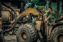 Photo story: Life of a scrap metal recycle worker
 Training of the PLA's first female honor guard
 China's 10 must-see animations
 Female bodybuilders show their beauty of fitness
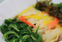 A taste of Harbin cuisine
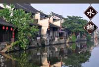 A bite of Jiang Nan
 Who is China's campus beauty queen?
 8 great movies to watch with your mom
 China's most luminous celebrities
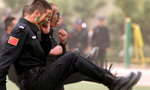 Newly recruited police in Hetian hold drill
  Bird-men compete flying in Hong Kong
  The 'Chinese Dad'
 Shanghai locals bid farewell to childhood memories
Day|Week|Month