NANNING, Feb. 6 -- The People's Liberation Army (PLA) finished a two-day drill on Friday, testing application of China's independently developed global satellite navigation system in combat in Guangxi Zhuang Autonomous Region.
The military used the Beidou Navigation Satellite System for precise positioning and navigating, real-time location reporting and data transmission over long distances, according to a news release from the PLA General Staff Headquarters.
It said that Beidou has allowed the armies to be more precise in command, weapon firing and logistics and that the technology has "been integrated into the PLA's modern command system and weapon platform".
Beidou is the Chinese equivalent of the United States' NAVSTAR Global Positioning System and Russia's Global Navigation Satellite System. Currently, Beidou owns 20 satellites.
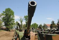 PLA soldiers operating vehicle-mounted guns in drill
 Beauties dancing on the rings
 Blind carpenter in E China's Jiangxi
 Top 10 highest-paid sports teams in the world
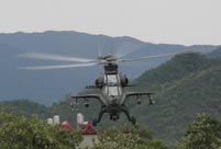 In photos: China's WZ-10 armed helicopters
 UFO spotted in several places in China
 Certificates of land title of Qing Dynasty and Republic of China
  Cute young Taoist priest in Beijing
 New film brings Doraemon's life story to China in 3D
 China-S.Korea FTA sets positive precedent
 Ferry carrying 458 people sinks in Yangtze River
 Mecca of Marxism
 Bring them home
Day|Week