BEIJING, March 6 -- China's most advanced earth observation satellite, the Gaofen-2, was put into service on Friday after being launched in August.
The services provided by the satellite will help boost development of the country's data application and spatial information sectors, said Xu Dazhe, head of the State Administration of Science, Technology and Industry for National Defense.
The Gaofen-2 is the second of seven satellites that will be launched for Gaofen, China's high-definition observation project, before 2020. The project was initiated in May 2010 and Gaofen-1 was launched in April 2013.
The goal of the Gaofen series is to provide all-weather, 24-hour services covering the globe.
The Gaofen-2 is able to see 0.8-meter-long objects from space in full color and collect multispectral images of objects 3.2 meters or longer, according to the administration.
The first photos taken by Gaofen-2 were published in late September. The stripes of a pedestrian crossing in the Xizhimen area of downtown Beijing were clearly visible in one of the photos.
Gaofen-2 provides services for more than ten Chinese government departments, including the ministries of land and resources and transport.
Xu said the government will also support non-governmental organizations, including private enterprises, in developing value-added services.
 China hosts overseas disaster relief exercise for the first time
 20 pairs of twins who will become flight attendants in Sichuan
 J-11 fighters in air exercise
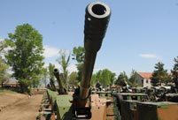 PLA soldiers operating vehicle-mounted guns in drill
 Beauties dancing on the rings
 Blind carpenter in E China's Jiangxi
 Top 10 highest-paid sports teams in the world
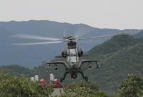 In photos: China's WZ-10 armed helicopters
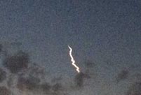 UFO spotted in several places in China
 Obama is sowing discontent in S.China Sea
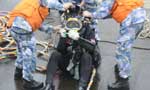 Rescuers work through night to reach cruise ship survivors
 Driving through limbo
 Facing down MERS
Day|Week