 |
| (File Photo) |
The strategic alliance of Asia-location services and smart city industrial technology innovation singed cooperative deals to promote the use of BeiDou Navigation Satellite System (BDS) with universities and companies from Laos, Myanmar, Indonesia, Bangladesh, Sri Lanka and Maldives at the Third China-ASEAN Expo on June 13, according to China News Service.
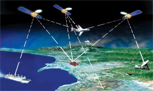
It indicates that China, as the third country with its self-developed satellite navigation system after the United States and Russia, begins to provide service in South Asian and Southeast Asian countries.
In addition to car navigation and information service and vehicle monitoring and management, Satellite navigation systems can also be used in many areas such as geological disaster monitoring and early warning, cross-border logistics, tourism, and ecological protection.
 Abandoned village swallowed by nature
 Graduation: the time to show beauty in strength
 School life of students in a military college
 Top 16 Chinese cities with the best air quality in 2014
 Mysterious “sky road” in Mount Dawagengzha
 Students with Weifang Medical University take graduation photos
 PLA soldiers conduct 10-kilometer long range raid
 Stars who aced national exams
 PLA helicopters travel 2,000 kilometers in maneuver drill
 Hillary’s speech offers clue to Sino-US ties
 'Smile diary' helps mother cope with son's leukemia
  Make me a genius
 Weak yen weighing on China’s exports
Day|Week