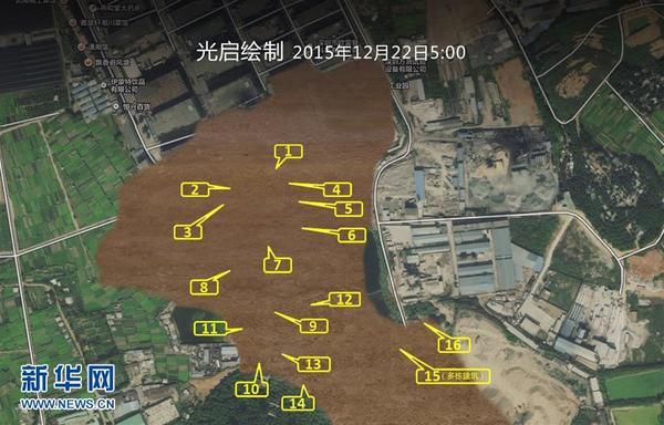
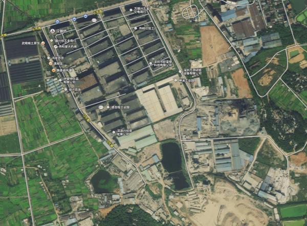
Underground Map shows Over 30 Buried Buildings at 16 Locations Detected in Shenzhen Landslide China’s Shenzhen Kuang-Chi Institute of Advanced Technology has submitted a map listing the 16 locations where 30 buildings were buried as key excavation areas to the Shenzhen landslide rescue team.
Applying aerial observation and thermal imaging technology, the institute compared the geographic information of the buried area before and after the landslide. According to Liu Ruopeng, director of the Shenzhen Kuang-Chi Institute, a crane equipped with multi-functional high resolution earth observer and an emergency response floating platform called “Cloud mini” were also used in the mapping.
“As most buildings were scattered from their original positions and buried deeply by the mud, it is very hard for the rescue team to locate excavation areas. The map, spotting nearly all the buried buildings, can assist the rescue work greatly,” Liu said.
 Are these the world’s scariest landing strips?
 In pics: Left behind children in China
 Eight modern day engineering marvels of China
 Chinese beauty with sexiest bottom
 Charming female bodybuilders of Chengdu University
 Polish sports stars strip off for risqué calendar
 Spectacular aerial photos of the Three Gorges
 Contestants of Mrs. Globe pose for photo in Shenzhen
 Bikini models attend hot pot banquet in Hefei
 Top 20 hottest women in the world in 2014
 Top 10 hardest languages to learn
 10 Chinese female stars with most beautiful faces
 China’s Top 10 Unique Bridges, Highways and Roads
Day|Week