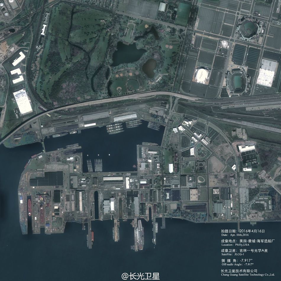
Photo taken by Jilin-1, China's first commercial remote sensing satellite, on April 16 shows The Navy Yard or the Philadelphia Naval Shipyard in the U.S. (Photo/Official Weibo account of Chang Guang Satellite Technology Co. Ltd)
A group of high-definition images of a shipyard in the U.S. taken by a Chinese satellite for commercial use went viral online on May 25, 2016, making some people ask whether it can be put into military use. An expert said that it is normal for a commercial satellite to take HD images of other countries.
According to a research by the Global Times, this group of images of The Navy Yard or the Philadelphia Naval Shipyard was taken on April 16 by Jilin-1, China's first commercial remote sensing satellite, produced by Chang Guang Satellite Technology Co. Ltd.
The images clearly show different types of ships and boats wharfing in the harbor of the shipyard including at least one aircraft carrier and several destroyers.
A Chinese expert who asked to be anonymous told the Global Times on Wednesday that Jilin-1 is China's first homegrown satellite named after a province and was launched in October 2015. The satellite complex consists of four satellites — two providing high-definition video, one for commercial high-definition images, and another for testing new space technology.
The expert said that it is normal for China's commercial satellite to capture images of objects on the ground of other countries. First, there is no territorial limit when it comes to aerospace. Satellites all over the world orbit and observe the Earth. Second, the resolution of Jilin-1 is 0.72 meters — high enough to catch aircraft carriers. Moreover, the satellite does not only focus on the U.S.; it has taken HD images of landmarks like the Bird Nest in Beijing. The company also released HD images of Cam Ranh Bay in Vietnam.
As a commercial entity, the company shows its ability to attract more clients. There is nothing to blame. Commercial satellite companies do the same thing as well, the expert added.
Although the satellite can take relatively clear images, there is certain gap compared with the most advanced international standards. The highest resolution of commercial remote sensing satellite is 0.31 meters and that of U.S. military optical reconnaissance satellite KH-12 is 0.1 meters.
The expert said that there is a new global trend to develop and apply small satellites. With the development of electronic technology, small satellites carry more functions and have a low production cost.
The expert said that China has put more efforts in launching and applying small satellites. According to short-term plans, northeast China's Jilin province is about to launch 60 civilian small satellites by 2020 and by 2030, there will be 138 on-orbit satellites.
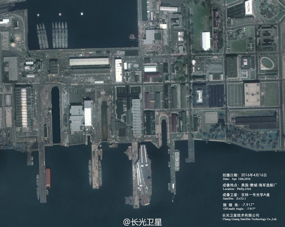
Photo taken by Jilin-1, China's first commercial remote sensing satellite, on April 16 shows The Navy Yard or the Philadelphia Naval Shipyard in the U.S. (Photo/Official Weibo account of Chang Guang Satellite Technology Co. Ltd)
Day|Week

 China's first intelligent security robot debuts in Chongqing
 A Total of 3,552 Subscribers Vanish In Two Days; YouTube Closes All Doors to Users’ Inquiries
 Out of this world! Futuristic UFO-shaped yacht has its own garden and a stunning underwater viewing deck
 An old tea house in Chengdu
 Furious Customer Crushes All the Buns from Vendor Just Because He Was Given the Wrong Flavor
 20 post-90s couples hold ’naked marriage‘ in E. China
 Female official wearing traditional Han costume to promote local tourism
 Over 12,000 Runners Seek Medical Care in S China’s Marathon
 Six Luxury Sports Cars Totaled after Fail Attempts to Cross China’s Most Perilous Highway Linking SW China’s Sichuan and Tibet
 Incredible Transformation: “Witch Child”Whose Parents Left Him for Dead in Nigerian Makes Speedy Recovery

