
NANJING, June 4 (Xinhua) -- A satellite exposition opened Tuesday in Nanjing, capital city of east China's Jiangsu Province, displaying the latest navigation technologies and products of BeiDou satellites.
The three-day exposition, the second China (Nanjing) BeiDou Satellite Navigation Application Expo, will attract 200 exhibitors and 5,000 visitors, according to its organizer.
Over 30 scholars and academicians from the satellite and smart industries will also participate in a forum held during the expo.
BeiDou satellite applications in drones, unmanned ships, surveying and mapping equipment, intelligent robots, vehicles and VR headsets will be showcased.
Named after the Chinese term for the Big Dipper constellation, China's BeiDou navigation system is one of the four space-based navigation networks operating globally, along with the U.S. GPS system, Russia's GLONASS and the European Union's Galileo.
The BeiDou system currently has 38 in-orbit satellites. China will launch six to eight new BeiDou satellites this year.
 Fire brigade in Shanghai holds group wedding
 Tourists enjoy ice sculptures in Datan Town, north China
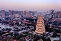 Sunset scenery of Dayan Pagoda in Xi'an
 Tourists have fun at scenic spot in Nanlong Town, NW China
 Harbin attracts tourists by making best use of ice in winter
 In pics: FIS Alpine Ski Women's World Cup Slalom
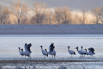 Black-necked cranes rest at reservoir in Lhunzhub County, Lhasa
 China's FAST telescope will be available to foreign scientists in April
 "She power" plays indispensable role in poverty alleviation
 Top 10 world news events of People's Daily in 2020
 Top 10 China news events of People's Daily in 2020
 Top 10 media buzzwords of 2020
 Year-ender:10 major tourism stories of 2020
 No interference in Venezuelan issues
 Biz prepares for trade spat
 Broadcasting Continent
 Australia wins Chinese CEOs as US loses