
BEIJING, May 27 (Xinhua) -- It will probably take two to three months for scientists to calculate and release the exact height of Mount Qomolangma, the world's highest peak, said China's Ministry of Natural Resources on Wednesday.
An eight-member Chinese survey team reached the summit of the mountain on Wednesday morning, erecting a survey marker and installing a GNSS antenna on the snow-covered peak. This marked the completion of the measurement field work.
With the measurement data, scientists will use multiple traditional and modern measurement techniques to perform comprehensive calculations. After data analysis and processing, they will further carry out theoretical studies and repeated verifications to determine the accurate height, the ministry sources said.
Complex calculations are needed to eliminate errors caused by factors such as temperature, air pressure and the refractive environment.
At the summit, the team members conducted a GNSS survey, snow depth measurement and gravity survey.
The GNSS survey was assisted by China's home-grown BeiDou Navigation Satellite System. The high-altitude gravity survey set a new world record as the highest of its kind.
 Fire brigade in Shanghai holds group wedding
 Tourists enjoy ice sculptures in Datan Town, north China
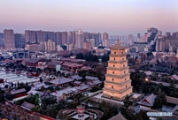 Sunset scenery of Dayan Pagoda in Xi'an
 Tourists have fun at scenic spot in Nanlong Town, NW China
 Harbin attracts tourists by making best use of ice in winter
 In pics: FIS Alpine Ski Women's World Cup Slalom
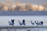 Black-necked cranes rest at reservoir in Lhunzhub County, Lhasa
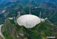 China's FAST telescope will be available to foreign scientists in April
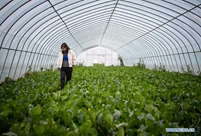 "She power" plays indispensable role in poverty alleviation
 Top 10 world news events of People's Daily in 2020
 Top 10 China news events of People's Daily in 2020
 Top 10 media buzzwords of 2020
 Year-ender:10 major tourism stories of 2020
 No interference in Venezuelan issues
 Biz prepares for trade spat
 Broadcasting Continent
 Australia wins Chinese CEOs as US loses