 |
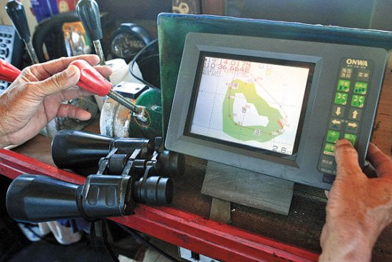
| Chen Yiping, captain of fishing boat Qiongqionghai 03889, uses Beidou navigation to guide the vessel to Huangyan Island for fishing. (China Daily/Huang Yiming) |
BEIJING, Sept. 10 -- China's indigenous satellite navigation system is achieving increasing market presence in the country, with most new GPS gadgets compatible with it, according to an industry report released on Thursday.
At least 80 percent of such gadgets and services sold in 2014 in China were compatible with the Beidou Navigation Satellite System(BDS), an alternative to U.S.-operated GPS, said the report by the CNSS and LBS Association of China.
Services based on the BDS have been used not only for industrial purposes such as geographic surveying, traffic monitoring and agriculture, but also car navigation and positioning services on mobile phones, the report said.
China launched the 18th and 19th satellites for the BDS in July, a step closer to the target of a complete constellation of 35 satellites and achieving global coverage by 2020.
According to the report, China's satellite navigation industry reported an annual revenue of 134.3 billion yuan (21.32 billion U.S. dollars) in 2014, up 29.1 percent from 2013.
 Models change clothes on street in Hangzhou
 Charming iron ladies in China's upcoming V-Day celebrations
 In pics: armaments displyed in massive military parade
 Charming Chinese female soldiers
 Volunteers required not taller than 5ft 5in
  Czech pole dancing master teaches in Xi'an
 Shocked! PLA smokescreen vehicle drill
 Foreigners experience tranditional Chinese wedding
 Blind date with bikini girls in Nanjing
 China’s ghost riders
  US hawks full of bluster ahead of Xi’s visit
 Measures prevented systemic financial risks: Premier Li
 France returning treasure to China sets precedent for further restitutions
 Day|Week